


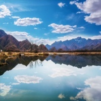
Shennongjia
Geomorphic formation
From the end of Indosinian movement to the beginning of Yanshan movement, strong folds and large-area tilting occurred in Shennongjia forest region, which laid the geomorphic framework of the region. The cold and warm changes of Quaternary climate left glacial landforms in some sections, resulting in complex and diverse landforms in the area. Shennongjia mountain range is located in the southwest of Shennongjia forest region in the east-west direction. Shennong top is the highest with an elevation of 3105.4 meters, which is also the highest point in Central China; The lowest point in the forest area is Shizhu River in xiaguping Township, with an elevation of 398m and a relative elevation difference of 2707.4m. According to the geomorphic morphological characteristics and genetic types in the area, it can be divided into four types of geomorphic units: structural dissolution geomorphology, dissolution erosion geomorphology, denudation erosion geomorphology and accumulation geomorphology.
Climatic characteristics
Shennongjia belongs to the north subtropical monsoon climate zone, which is the transition zone from subtropical climate to temperate climate. It is humid and rainy in summer and mild and rainy in winter. The annual radiation is 103.7 kcal / m2, and the annual sunshine hours are 1858.3 hours. The sunshine hours and total radiation amount decrease with the increase of altitude. The annual average temperature frost free period varies greatly with the altitude. The annual precipitation is 800-2500 mm, and the precipitation increases with the increase of altitude. At the turn of spring and summer, frost often occurs, generally from the end of September to the end of the next April. The average annual evaporation in the region is 500-800 mm, and the drought index is 0.50-0.53. Southeast wind prevails 80% of the year.

Website column
Contact us
Beijing Demi Zhongmao International Trade Co., Ltd
Address: Room 2016, 2/F, Building No.23, East Hui Xin Street, Chaoyang District, Beijing, China
Postal Code: 100029
Tel:+86(10)64968320 / +86(10)64968321
Fax:86(10)64911005
Mailbox:bjgac@bjgac.com
Website:www.bjgac.com